![]()
Cataloger's Reference Shelf
Map Cataloging Manual
![]()
Cataloger's Reference Shelf
Map Cataloging Manual
Mathematical and Other Cartographic Data
Grids and Ellipsoids:
Record information on grids and ellipsoids if stated on the item and if considered important. Examples:
Meridian:
Record the primer meridian if stated on the item and if other than Greenwich. The prime meridian is the north-south reference line on the earth’s surface (i.e., 00 longitude) from which longitude is measured.
Beginning in 1884 the Greenwich meridian, which passes thought Greenwich, England, neat London, has been almost universally accepted as the prime meridian. For items published before 1800 the London meridian is assumed to be the same as the Greenwich meridian.
For items produced prior to 1884, meridians other than Greenwich were often adopted. Items published in the United States frequently used Philadelphia, Washington, or New York as the prime meridian. In some instances items identify two different prime meridians. Examples:
In addition to the prime meridian, record any local or principal meridian(s) identified on the item. A principal meridian is often indicated on items produced by the U.S. Forest Service. Examples:
Orientation:
Most maps are drawn with north oriented at or near the top of the item.
Whenever north is positioned at an angle of 45 degrees or more from the top of the map a note is included to indicate the orientation. Orientation of an item cam be determined from an indication on the map (e.g., compass rose, latitude lines, etc.), personal from an indication on the map (e.g., compass rose, latitude lines, etc.), personal knowledge, or, if readily available, comparison with other maps of the same area.
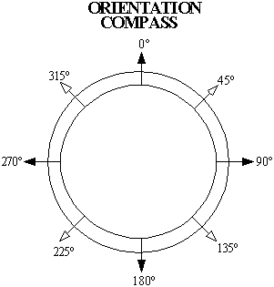
When north is positioned at an angle of 90, 180, or 270 degrees from the top of the item the phrase Oriented with north to the ... is used to introduce the note. Example:
When north is positioned at an angle between 45 and 315 degrees from the top of the item (excluding angles of 90, 180, and 270 degrees) the phrase Oriented with north toward the ... is used to introduce the note. Example:
See also: